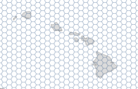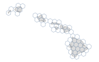
The GenerateTessellations task creates tessellations, or bins, determined by a specified extent, shape, and size.
For example, for reforestation projects, foresters need to divide harvested areas into bins, or regularly shaped areas, to understand the amount of seedlings and resources needed to reforest the area effectively. The GenerateTessellations task can be used to automatically create a dataset of appropriately sized bins for the full study area.
Request URL
http://<analysis url>/GenerateTessellations/submitJobRequest parameters
| Parameter | Description | ||||||||||
|---|---|---|---|---|---|---|---|---|---|---|---|
binType (Required) | Specifies the tessellation shape. Bin options are as follows:
Example: "binType" : "Hexagon" | ||||||||||
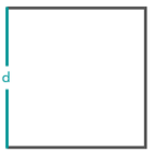
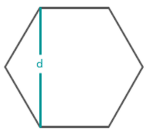
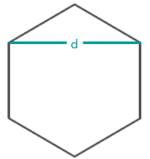
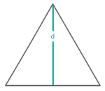
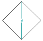
binSize Required if binType is not H3_Hexgon | The size of each bin. Cell size can be determined by specifying square units or by specifying a distance that is calculated using the following measurements in which d = Distance:
Example: "binSize" : 100 | ||||||||||
binSizeUnit Required if binType is not H3_Hexgon | Specifies the linear or areal unit to be used with the value specified in binSize. Values: Meters | Kilometers | Feet | Miles | NauticalMiles | Yards | SquareKilometers | Hectares | SquareMeters | SquareMiles | Acres | SquareYards | SquareFeet | SquareInches The default is SquareKilometers. Example: "binSizeUnit" : "Miles" | ||||||||||
extentLayer | The extent that the tessellations will cover. Syntax: As described in detail in the Feature input topic, this parameter can be one of the following:
Examples:
| ||||||||||
intersectStudyArea | A Boolean value that specifies whether only tessellations that intersect with the extent layer (extentLayer) will be kept. The default is false. This parameter is only applied if an extent layer has been provided.
Values: true | false | ||||||||||
binResolution Required if binType is H3_Hexgon | The H3 resolution of the tessellations. The resolution can range from 0 to 15. With each increasing resolution size, the area of the polygons will decrease to one-seventh the size at the lower resolution. Learn more about H3 resolution This parameter is available in ArcGIS Online and ArcGIS Enterprise11.2 or later. REST examples | ||||||||||
outputName | If provided, the task will create a feature service of the results. You define the name of the service. If an outputName value is not provided, the task will return a feature collection. Syntax: Syntax: | ||||||||||
context | The Context parameter contains the following additional settings that affect task operation:
Syntax: | ||||||||||
f | The response format. The default response format is html. Values: html | json |
Response
When you submit a request, the service assigns a unique job ID for the transaction.
{
"jobId": "<unique job identifier>",
"jobStatus": "<job status>"
}
After the initial
request is submitted you can use the
jobId value to periodically check the status of the job and messages as described in the Checking job status topic.
Once the job has successfully completed, use
the jobId value to retrieve the results. To track the status, you can make a request of the following form:http://<analysis url>/GenerateTessellations/jobs/<jobId>
Access results
When the status of the job request is esriJobSucceded, you can access the results of the analysis by making a request of the following form:http://<analysis url>/GenerateTessellations/jobs/<jobId>/results/<output parameter name>?token=<your token>&f=json
| Parameter | Description |
|---|---|
tessellationLayer |
tessellationLayer will always contain polygon features.
The result has properties for parameter name, data type, and value. The contents of value depend on the outputName parameter value provided in the initial request.
See Feature output for more information about how the result layer or collection is accessed. |
